


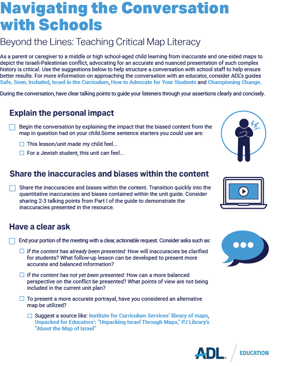
Beyond the Lines: Teaching Critical Map Literacy
Maps are an integral and necessary tool for educators to use with students—they imply trust, objectivity and fact. It is through maps that students learn about the wider world, historical events and conflicts, the movement of peoples throughout time, etc. Maps, however, are not only simple graphic reproductions of a region. While geographic features like rivers, mountains, and coastlines are objective aspects of the landscape, political and cultural features like borders and place names change in response to events in human history. This overlay of historical information must therefore accurately reflect the political and cultural realities of the period a map portrays.
As more and more educators supplement their instructional materials with free online resources, biased and inaccurate content like downloaded maps can frame historical facts in a misleading way for students. The guidance below demonstrates the importance of carefully and deliberately selecting maps for classroom instruction, and how to how to respond when the maps utilized in the classroom push a particular agenda and narrative.
Teaching with Maps: Why Context and Accuracy Matter
Publicly available maps can be inaccurate or misleading; when used as teaching aids, such biased maps can create a distorted sense of events. For this reason, educators should take care when choosing whether and how to use publicly available maps for instructional purposes, especially when covering complex and ongoing topics like the Israeli-Palestinian conflict.
For example, a map of the region that includes modern-day Israel, Gaza, and the West Bank but focuses on the years 1920-1948 should use the place names and geopolitical terms that were in use during that time period—terms like: British Mandate Palestine, French Mandate Syria, Transjordan, etc.
Explore the sections below for more insight into some common problems with publicly available maps related to the Israeli-Palestinian conflict and recent examples of their misuse in educational settings, along with advocacy tools to assist in facilitating productive conversations with educators when these inaccurate resources are used in the classroom.
Part I: What Can Make a Map Problematic?
Use the drop-downs below to explore specific aspects related to maps used in reference to the Israeli-Palestinian conflict to learn more about what can make them problematic and what to look out for.
We look at maps as unbiased, fact-based resources that can be used to study things like global conflicts, shifting borders, etc. But maps can also be constructed to include historical inaccuracies and frame a particular narrative, especially when used with a topic as nuanced as the Israeli-Palestinian conflict.
- For example, a publicly released New York State Regents Exam in Global History and Geography from 2019 features two historical maps of the region which today contains Israel, Gaza, and the West Bank (pg. 8).
- The first map, meant to portray the region from 1920-1948, does not clearly show the borders of the British Mandate and uses the ambiguous geographical term “Palestine” in the title rather than the more accurate “British Mandate for Palestine.”
- The maps, meant to portray the region from 1920-1948 lack basic factual information. They ignore the demographic reality of the region under the British Mandate which included Arabs, Jews, Christians and others. Further, the first map paints Jewish settlements as something new and nefarious, omitting the fact that Jews have lived continuously in the region for over 3,500 years.
- The other map accurately shows the borders of the 1947 U.N. Partition Plan, but misleadingly implies that the plan proposed a Jewish state and not an Arab state.
- The questions posed with the two maps do not acknowledge the historical and cultural ties that Jews have to the land, inadvertently reinforcing the idea that Jews are not indigenous to the region and erasing Jewish history in the land.
- Given that curriculum developers and teachers understandably trust maps used in a state test, those same maps appeared in instructional materials, thus perpetuating the spread of misleading and inaccurate historical information. This case underscores the importance of providing educators with accurate maps from trusted sources.
The names that we read on maps are incredibly important—they ground conversations through shared language, anchor students in a sense of place and allow an accurate reference of locations students are discussing. Maps are snapshots in time, and the world is ever-changing. Therefore context is critical in exploring such snapshots of time and place. It is for this reason that utilizing incorrect and historically inaccurate names when referring to land related to the Israeli-Palestinian conflict can easily skew the perception of the conflict to communicate a specific narrative.
- In some recent prominent cases, maps have left out the name of the State of Israel entirely, labeling the whole region “Palestine.” Beyond propagating a glaring inaccuracy, districts that use maps that erase the State of Israel risk being deemed discriminatory against Jewish students by state departments of education.
- This was the case with the Oakland Unified School District, which shared maps of the Middle East that only labeled Palestine. The California Department of Education released a report finding that the curriculum approved by OUSD “constituted discrimination towards Jewish persons,” highlighting the consequences of materials that do not support an inclusive environment for all students.
- Similarly, the National Education Association drew fierce criticism for sharing resources including a world map that also labeled only “Palestine.” In addition to the erasure of the State of Israel, the resources also included links to organizations that justified the October 7th Hamas attack against Israel.
- When selecting maps for classroom use, teachers need to critically consider the historical time period they are discussing—if they are discussing the British Mandate period or the time of the Ottoman rule, maps need to be labeled with correct terminology and presented with the necessary contextual information. So too should modern maps be selected that include the State of Israel alongside other internationally recognized states.
While maps are viewed as an objective and useful instructional resource, they do not exist in a void. Maps themselves are insufficient for understanding complex historical and current events without adequate, accurate context and explanation. Conversely, instructional materials often include maps that are ostensibly accurate, but that are presented within a biased or inaccurate context.
- For instance, the interactive map in this source from Al Jazeera1 accurately depicts the borders for the proposed Jewish and Arab states under the U.N. Partition Plan of 1947. However, the accompanying description claims that the “Palestinians rejected the proposal because it stripped away much of the land that was under their control.” The resource does not include any background information explaining that, before 1947, the entire region was controlled by the Ottoman and then British empires, not by Palestinian Arabs.
- The framing of the map implies that Jewish presence in the land began only in 1917, which is both misleading and historically inaccurate.
- The cadence of this source tells an inaccurate narrative of Israel slowly taking over more and more land, presumably away from the Palestinians. It does not clearly indicate the governmental structure of the British Mandate of Palestine, which included Jews, Arabs, and others living there nor the topographical nature of much of this land as uninhabitable desert.
- When utilizing maps for classroom instruction, it is just as important that educators provide accurate and unbiased context for the historical information—taking the time to tell the full story of the history of land and issues like the Israeli-Palestinian conflict.
- See: Jerusalem Center for Security and Foreign Affairs, Al Jazeera–Feeding the Muslim Brotherhood’s Political Agenda to the Arab World, 2024
Conclusion
Without extensive knowledge about the Israeli-Palestinian conflict, it can be difficult for teachers to identify reliable map resources when covering this historical topic, especially when there are so many online options that purport to be reputable sources. To mitigate the risk of choosing inaccurate or biased maps, teachers should:
- Provide historical context: ensure every map is accompanied by a rigorous and comprehensive historical curriculum that gives students the necessary context to understand the region depicted.
- Examine the surrounding contextual information, questions and instructional context in which maps are embedded, including any headers, captions, or citations/credits. If the surrounding content contains biased or inaccurate information, the map should be shown only with the appropriate context and caveats.
- Evaluate more recently created maps of the Israeli-Arab or Israeli-Palestinian conflicts by comparing them to original maps, such as the map of the U.N. Partition Plan drafted in 1947 by the United Nations Special Committee on Palestine. It is important to utilize and compare different versions of maps to demonstrate the progression of history.
- Consult reliable resources such as historically accurate maps from trusted collections, including the Institute for Curriculum Services’ library of maps, Unpacked for Educators’: “Unpacking Israel Through Maps,” PJ Library’s “About the Map of Israel” to provide context and serve as a reference for evaluating other maps.
Part III: Additional Resources
- Championing Change: How Parents and Families Can Address Antisemitism in Schools
- Safe, Seen, Included: A Family Toolkit for Supporting Jewish Students
- How to Advocate for Your Students at their K-12 School
- Israel in the Curriculum
- Antisemitism Today
- The New Antisemitism and the Three Ds
- A Brief History of Israel
- Institute for Curriculum Services’ library of maps
- Unpacked for Educators’: “Unpacking Israel Through Maps,”
- PJ Library’s “About the Map of Israel”
- For a more in-depth exploration of how maps can be used as narrative tools, consider The iCenter’s Maps as Narratives curriculum.